


From Kaliningrad to Crimea, military outposts interfere with Ukrainian drones, but also disrupt civilian flights. In 2024, the cases increased by 220%.
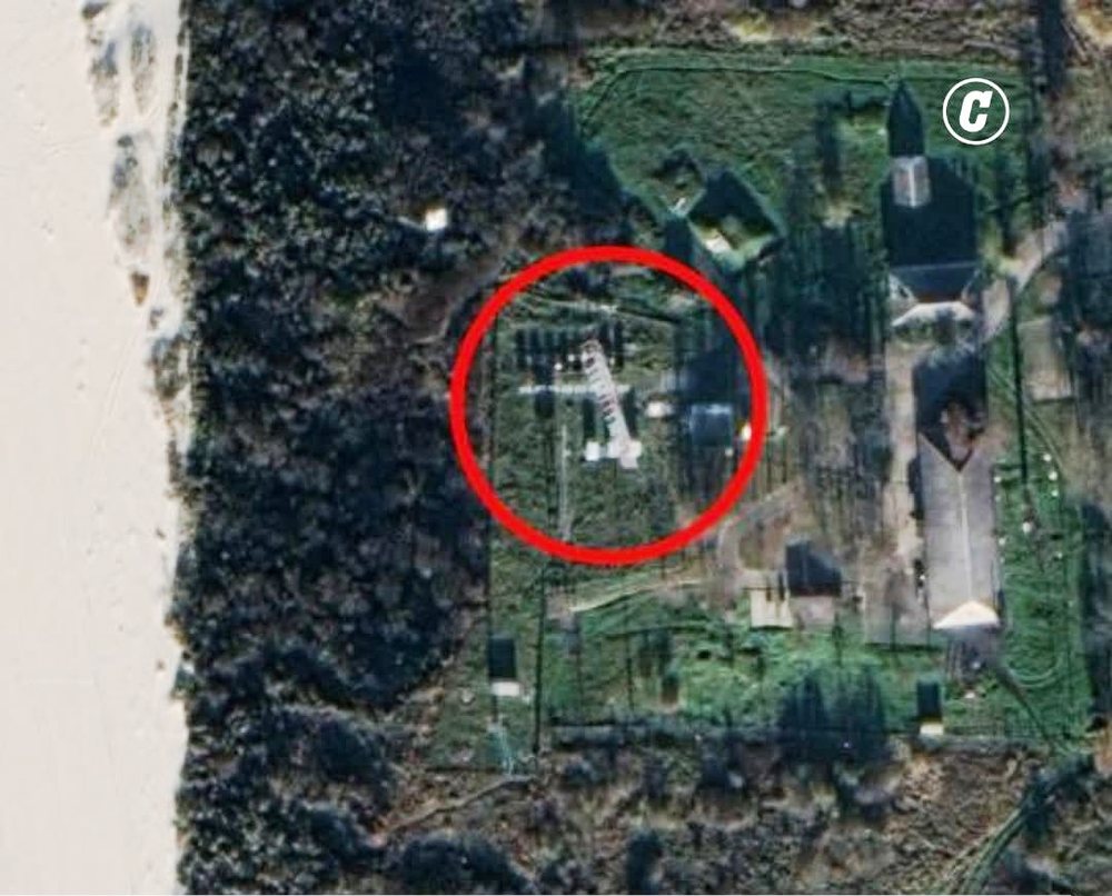
A giant 40-meter-high antenna in Kaliningrad, suddenly appearing near Okunevo, in the former Russian enclave between Poland and Lithuania and overlooking the Baltic Sea, has become one of the main sources of interference in the navigation systems of aircraft and ships — even at distances of hundreds of kilometers — since 2022, when Russia launched its large-scale invasion of Ukraine.
To identify it, experts from several countries used triangulation and satellite images. In Brussels, NATO headquarters, several European generals have proposed destroying or disabling it, a Western source told the Corriere della Sera newspaper. But this idea has been rejected, partly because of American opposition, and partly for fear of escalating the conflict.
Wide network of interventions
Okunevo's antenna is not the only one. Other similar sites have been discovered in Baltiysk, Yantarnyy, near St. Petersburg, and along the border with Ukraine. Also on the border with Estonia, authorities in Tallinn in June accused Russia of placing additional interception devices about 20 km from the border.
These are permanent or mobile posts, some visible from satellite, some camouflaged. They are mainly managed by:
16th Brigade in Kursk (near the eastern border with Ukraine)
The 218th Regiment, specialized units in electronic warfare.
More than 3 years of problems
For more than three years, dozens of aircraft flying between Europe and the Middle East have been facing problems receiving and transmitting satellite data during flight.
Moscow officially says it uses these devices to disrupt the navigation of Ukrainian drones, but in reality, the side effects seriously affect civilian aircraft and ships, damaging global positioning systems (GPS).
Statistics
According to a Stanford University monitoring platform, last August 90 to 150 aircraft reported serious problems with onboard instruments every day.
According to OpsGroup, a specialized platform for the aviation industry, last year 1,400 flights per day lost GPS signal in the Europe-Middle East-Russia areas.
According to IATA (International Air Transport Association), cases of GPS signal loss have increased by 220% between 2021 and 2024. Last year there were 56.3 cases for every 1,000 flights.
Types of interventions
Experts explain that interventions occur in two forms:
Jamming – signal blocking
Spoofing – changing location data
These interventions have caused:
Flight diversions, such as in January when a Ryanair Boeing 737, bound for Vilnius (Lithuania), was forced to land in Poland.
Canceling all routes, as Finnair did for a month on flights to Tartu, in eastern Estonia.
Temporary closure of airports.
Bulgaria is also in the affected area — Ursula von der Leyen's plane had problems landing in this country.
Increasingly sophisticated interventions
"Interventions are evolving in terms of frequency and complexity," Jesper Rasmussen, director of flight standards at EASA, the European aviation safety agency, said recently.
According to OpsGroup, high-altitude spoofing has caused:
Problems with the flight management system
Problems with the hybrid inertial reference (which tracks the aircraft's position)
Problems with the plane's clock
Problems with anti-collision systems, weather radar, communications between the pilot and the tower, as well as transponders that transmit identification data.
Debate at the UN
"With geopolitical tensions continuing, it is difficult to foresee any improvement in this situation in the near future," Nick Careen, IATA's vice president for operations and safety, said at an event in June.
For this reason, airlines are seeking official intervention from ICAO, the United Nations agency for civil aviation.
But there, Russia still has a say!
Source: Corriere della Sera